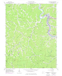
1963 Map of Chapmanville
USGS Topo · Published 1977About this map
The Guyandotte River carves a deep valley through this West Virginia coal country landscape, anchoring the town of Chapmanville and its surrounding communities. Along the riverbank, the Chesapeake and Ohio railroad corridor facilitates the region's industry, connecting the Strip Mine and local tipples to wider markets. The map reveals a dense network of family-named hollows and ridges, such as Conley Hollow and Pigeonroost Branch, where generations established remote homesteads, small schools like Piney Fork Sch, and numerous family burial grounds including Dingess Cem and the Blair Cems.
Find a feature on this map
95 named features on this map. Tap any name to fly to it.
Don’t see what you’re looking for? This feature index may not catch every label — zoom into the map to look around manually.
Map Details
Editions of this 1963 Chapmanville Map
3 editions found
Other maps of this area

1887 · Warfield
USGS Topo · 1:125,000

1891 · Oceana
USGS Topo · 1:125,000

1891 · Warfield
USGS Topo · 1:125,000

1892 · Huntington
USGS Topo · 1:125,000

1893 · Oceana
USGS Topo · 1:125,000

1898 · Huntington
USGS Topo · 1:125,000

1898 · Oceana
USGS Topo · 1:125,000

1899 · Charleston
USGS Topo · 1:125,000

1902 · Midkiff
USGS Topo · 1:62,500

1907 · Midkiff
USGS Topo · 1:62,500