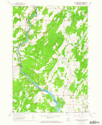
1963 Map of Chappee Rapids
USGS Topo · Published 1964About this map
The Menominee River serves as the dividing line between Wisconsin and Michigan in this mid-century survey, specifically marking the boundary between Porterfield and Menominee. This borderland landscape is defined by the river’s descent through Chappee Rapids and the numerous small tributaries like Sobiesky Creek, Martin Creek, and Kelley Creek that feed into the main channel. The map reveals a rural economy centered on transportation and land use, with the Chicago Milwaukee St Paul and Pacific railroad cutting through the southwestern corner and numerous gravel pits scattered throughout the glacial terrain.
Find a feature on this map
24 named features on this map. Tap any name to fly to it.
Don’t see what you’re looking for? This feature index may not catch every label — zoom into the map to look around manually.
Map Details
Editions of this 1963 Chappee Rapids Map
2 editions found
Other maps of this area

1939 · Marinette
USGS Topo · 1:48,000

1939 · Porterfield
USGS Topo · 1:48,000

1942 · Porterfield
USGS Topo · 1:48,000

1942 · Wausaukee
USGS Topo · 1:48,000

1947 · Wausaukee
USGS Topo · 1:48,000

1949 · Stephenson
USGS Topo · 1:48,000

1954 · Escanaba
USGS Topo · 1:250,000

1957 · Escanaba
USGS Topo · 1:250,000

1958 · Escanaba
USGS Topo · 1:250,000

1963 · Porterfield
USGS Topo · 1:62,500