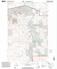
1997 Map of Charbonneau
USGS Topo · Published 2001About this map
Charbonneau Creek and its many tributaries, including Lonesome Creek and Antelope Creek, dominate this portion of the Little Missouri National Grassland. The landscape is a network of drainage basins and high points like Bull Butte, where the geography dictated the placement of early 20th-century ranching operations. Traces of local history are evident in the presence of the Nameless Cem and a second Cem near the northern boundary, alongside family-named landmarks such as the G Jacobson Ranch and J Kuykendall Ranch. Modern infrastructure intersects this rural setting via the Northern Border Pipeline and Cartwright Road. The map also reveals the importance of water management in this arid region, marking several water sources like the Jacobson Flowing Well and Jackson Dam, which provided essential resources for both livestock and residents in McKenzie County.
Find a feature on this map
23 named features on this map. Tap any name to fly to it.
Don’t see what you’re looking for? This feature index may not catch every label — zoom into the map to look around manually.
Map Details
Editions of this 1997 Charbonneau Map
This is the sole edition of this map. No revisions or reprints were ever made.
Other maps of this area

1953 · Watford City
USGS Topo · 1:250,000

1957 · Watford City
USGS Topo · 1:250,000

1967 · Watford City
USGS Topo · 1:250,000
1968 · Buford
USGS Topo · 1:24,000

1969 · Cartwright NE
USGS Topo · 1:24,000

1972 · Alexander
USGS Topo · 1:24,000

1972 · Horse Creek School
USGS Topo · 1:24,000

1972 · Moline School
USGS Topo · 1:24,000

1972 · Charbonneau
USGS Topo · 1:24,000

1972 · Sather Lake
USGS Topo · 1:24,000