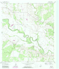
1963 Map of Charco
USGS Topo · Published 1987About this map
The meandering San Antonio River defines the lower Goliad County landscape in this 1960s era survey, where established ranchlands met a burgeoning petroleum economy. The community of Charco serves as a northern anchor, while smaller settlements like Angel City and the Riverdale (Site) dot the territory. Genealogists will find significant value in the documentation of family-named burial grounds including John Pettus Cem, Lott Pettus Cem, and San Jacinto Cem, which preserve the history of early settlers along the river's winding course.
Find a feature on this map
24 named features on this map. Tap any name to fly to it.
Don’t see what you’re looking for? This feature index may not catch every label — zoom into the map to look around manually.
Map Details
Editions of this 1963 Charco Map
2 editions found
Other maps of this area

1953 · Beeville
USGS Topo · 1:250,000

1956 · Beeville
USGS Topo · 1:250,000

1960 · Beeville
USGS Topo · 1:250,000

1962 · Melo
USGS Topo · 1:24,000

1962 · Goliad
USGS Topo · 1:24,000
1963 · Choate
USGS Topo · 1:24,000

1963 · Lazy F Ranch
USGS Topo · 1:24,000

1963 · Weesatche
USGS Topo · 1:24,000
1963 · Berclair NW
USGS Topo · 1:24,000

1963 · Berclair
USGS Topo · 1:24,000