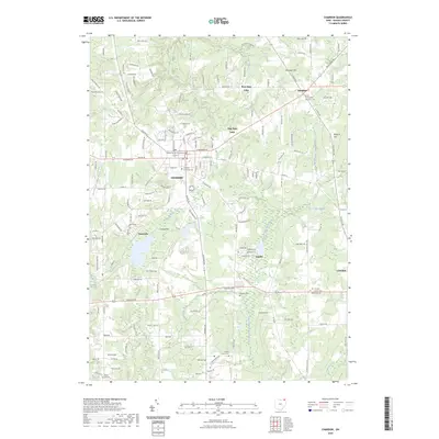
2023 Map of Chardon
USGS Topo · Published 2023About this map
Chardon serves as the focal point of this Geauga County landscape, anchored by the Geauga County Courthouse and a dense network of residential streets. The terrain is defined by its glacial hydrology, with significant water bodies like Bass Lake, East Bass Lake, and Lake Aquilla providing natural drainage into the Chagrin River and the West Branch Cuyahoga River. Smaller settlements such as Hambden, Aquilla, and Claridon dot the surrounding highlands, including Wooddin Hill and Ballards Hill. For those researching local lineages, several burial grounds are recorded, including the Chardon Municipal Cem, Hambden Township Cem, and the specialized County Home Cem. The map illustrates a rural-to-suburban transition, where long-standing family-named roads like Mitchells Mill Rd and Hosford Rd connect historic crossroads and scattered farmsteads.
Find a feature on this map
150 named features on this map. Tap any name to fly to it.
Don’t see what you’re looking for? This feature index may not catch every label — zoom into the map to look around manually.
Map Details
Editions of this 2023 Chardon Map
This is the sole edition of this map. No revisions or reprints were ever made.
Other maps of this area

1904 · Chardon
USGS Topo · 1:62,500

1905 · Garrettsville
USGS Topo · 1:62,500

1905 · Mentor
USGS Topo · 1:62,500

1906 · Chardon
USGS Topo · 1:62,500

1906 · Chagrin Falls
USGS Topo · 1:62,500

1907 · Garrettsville
USGS Topo · 1:62,500

1907 · Mentor
USGS Topo · 1:62,500

1908 · Chagrin Falls
USGS Topo · 1:62,500

1950 · Cleveland
USGS Topo · 1:250,000

1953 · Chardon
USGS Topo · 1:24,000