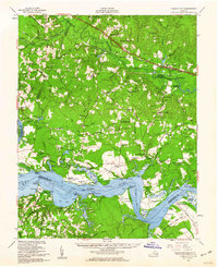
1953 Map of Charles City
USGS Topo · Published 1960About this map
The James River and the Chickahominy River define this colonial heartland, where centuries of Virginia history are etched into the landscape. Along the north bank of the James, famous estates such as Westover, Evelynton Plantation, and Berkeley sit among the many bends and reaches, including Threemile Reach. To the south, in Prince George County, the map records Flowerdeu Hundred and Merchant Hope Ch, surrounded by early drainage networks like Chappell Creek.
Find a feature on this map
120 named features on this map. Tap any name to fly to it.
Don’t see what you’re looking for? This feature index may not catch every label — zoom into the map to look around manually.
Map Details
Editions of this 1953 Charles City Map
2 editions found
Other maps of this area

1894 · Bermuda Hundred
USGS Topo · 1:62,500

1894 · Petersburg
USGS Topo · 1:62,500

1894 · Richmond
USGS Topo · 1:62,500

1895 · Richmond
USGS Topo · 1:62,500

1917 · Toano
USGS Topo · 1:62,500

1918 · Charles City
USGS Topo · 1:62,500

1918 · Toano
USGS Topo · 1:62,500

1919 · Surry
USGS Topo · 1:62,500

1919 · Disputanta
USGS Topo · 1:62,500

1919 · New Kent
USGS Topo · 1:62,500