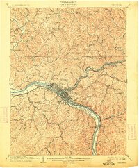
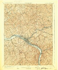
1909 Map of Charleston
USGS Topo · Published 1914About this map
Charleston and its surrounding industrial riverfront are captured during a period of significant growth along the Kanawha River. The convergence of the Elk River and the Kanawha serves as the geographic anchor for the region, where the Kanawha and Michigan and Chesapeake and Ohio railroads parallel the water, facilitating the area's coal and manufacturing economy. Small mining and post office hubs like Mason Sta Graham Mines PO and Garnet PO Malden Sta show the early development of outlying communities such as South Charleston and Malden.
Find a feature on this map
96 named features on this map. Tap any name to fly to it.
Don’t see what you’re looking for? This feature index may not catch every label — zoom into the map to look around manually.
Map Details
Editions of this 1909 Charleston Map
6 editions found

Other maps of this area

1897 · Kanawha Falls
USGS Topo · 1:125,000

1899 · Charleston
USGS Topo · 1:125,000

1900 · Kanawha Falls
USGS Topo · 1:125,000

1901 · Kanawha Falls
USGS Topo · 1:125,000

1906 · Kenna
USGS Topo · 1:62,500

1906 · Winfield
USGS Topo · 1:62,500

1906 · Walton
USGS Topo · 1:62,500

1907 · Kenna
USGS Topo · 1:62,500

1907 · Walton
USGS Topo · 1:62,500

1907 · Clendenin
USGS Topo · 1:62,500