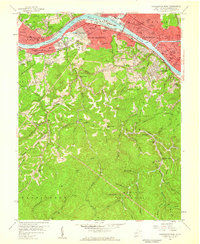
1958 Map of Charleston West
USGS Topo · Published 1959About this map
The Naval Ordnance Plant stands as a prominent industrial landmark on the southern bank of the Kanawha River, anchoring a landscape where heavy industry and residential expansion meet the steep terrain of the Appalachians. By the late 1950s, the urban footprints of Charleston, South Charleston, and Dunbar were well-defined, linked by the New York Central and Chesapeake and Ohio railroads. While the riverfront is dominated by infrastructure like the Sewage Disposal and Recreation Center, the southern half of the map reveals a different character. Here, narrow hollows such as Shrewsbury Hollow and Polly Hollow wind through the ridges toward the protected acreage of the Kanawha State Forest. Small rural settlements and institutions like Ivydale, Loudendale, and the Midkiff Sch illustrate the persistent community life in the hills just beyond the city's industrial edge.
Find a feature on this map
119 named features on this map. Tap any name to fly to it.
Don’t see what you’re looking for? This feature index may not catch every label — zoom into the map to look around manually.
Map Details
Editions of this 1958 Charleston West Map
4 editions found
Other maps of this area

1899 · Charleston
USGS Topo · 1:125,000

1909 · Charleston
USGS Topo · 1:62,500

1909 · Peytona
USGS Topo · 1:48,000

1909 · Saint Albans
USGS Topo · 1:62,500

1911 · Peytona
USGS Topo · 1:62,500

1911 · Madison
USGS Topo · 1:62,500

1929 · Madison
USGS Topo · 1:62,500

1929 · Peytona
USGS Topo · 1:62,500

1931 · Madison
USGS Topo · 1:62,500

1931 · Saint Albans
USGS Topo · 1:62,500