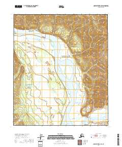
2018 Map of Charley River A-1 SW
USGS Topo · Published 2018About this map
The Yukon River carves a massive path through the center of this landscape, its wide channel and shifting bars defining the geography of the Yukon-Charley Rivers National Preserve. To the north, Montauk Bluff rises sharply from the riverbank, while the southern terrain is dominated by the high peaks of the Mertie Mountains and the prominent Waterfall Mtn. This area represents a largely roadless interior, where the Tatonduk River joins the Yukon system amidst a vast expanse of wetlands and steep topographic relief. The map reveals the intricate network of the National Hydrography Dataset, illustrating the drainage patterns that have shaped this subarctic wilderness long before its formal preservation.
Find a feature on this map
12 named features on this map. Tap any name to fly to it.
Don’t see what you’re looking for? This feature index may not catch every label — zoom into the map to look around manually.
Map Details
Editions of this 2018 Charley River A-1 SW Map
This is the sole edition of this map. No revisions or reprints were ever made.
Other maps of this area

1899 · Fortymile
USGS Topo · 1:250,000

1951 · Charley River
USGS Topo · 1:250,000

1951 · Eagle
USGS Topo · 1:250,000

1956 · Charley River A-2
USGS Topo · 1:63,360

1956 · Charley River A-1
USGS Topo · 1:63,360

1956 · Charley River
USGS Topo · 1:250,000

1956 · Eagle D-2
USGS Topo · 1:63,360
1956 · Eagle D-1
USGS Topo · 1:63,360

1957 · Eagle
USGS Topo · 1:250,000
2018 · Charley River A-2 NE
USGS Topo · 1:25,000