
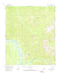
1956 Map of Charley River A-1
USGS Topo · Published 1960About this map
The Yukon River carves a massive path through the western portion of this terrain, meeting the Tatonduk River in a landscape defined by dramatic elevation changes and remote outposts. This 1950s-era survey captures a segment of the international border between the United States and Canada, showing the isolation of the Alaskan interior just before statehood. A small Cabin and the site of Millers Camp (Aban'd) provide evidence of human presence along the riverbanks, likely serving as stops for trappers or miners navigating these waterways. Inland, the topography rises sharply toward Three Castle Mountain and Jones Ridge. Watercourses like Hard Luck Creek and Cathedral Creek drain the high country, while a solitary Pingo is noted in the northern section, highlighting a distinctive permafrost landform characteristic of the subarctic environment.
Find a feature on this map
18 named features on this map. Tap any name to fly to it.
Don’t see what you’re looking for? This feature index may not catch every label — zoom into the map to look around manually.
Map Details
Editions of this 1956 Charley River A-1 Map
2 editions found
Other maps of this area

1899 · Fortymile
USGS Topo · 1:250,000

1951 · Charley River
USGS Topo · 1:250,000

1951 · Eagle
USGS Topo · 1:250,000
1956 · Charley River B-1
USGS Topo · 1:63,360

1956 · Charley River B-2
USGS Topo · 1:63,360

1956 · Charley River A-2
USGS Topo · 1:63,360

1956 · Charley River
USGS Topo · 1:250,000

1956 · Eagle D-2
USGS Topo · 1:63,360
1956 · Eagle D-1
USGS Topo · 1:63,360

1957 · Eagle
USGS Topo · 1:250,000