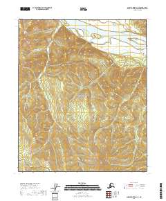
2018 Map of Charley River A-2 SE
USGS Topo · Published 2018About this map
The Yukon-Charley Rivers National Preserve encompasses this interior Alaskan landscape, dominated by the sweeping passage of the Yukon River through the northern portion of the quadrangle. The terrain rises sharply from the riverbanks towards the Mertle Mountains in the northwest, while the Montauk Bluff provides a distinctive vertical landmark along the eastern water’s edge.
Find a feature on this map
19 named features on this map. Tap any name to fly to it.
Don’t see what you’re looking for? This feature index may not catch every label — zoom into the map to look around manually.
Map Details
Editions of this 2018 Charley River A-2 SE Map
This is the sole edition of this map. No revisions or reprints were ever made.
Other maps of this area

1899 · Fortymile
USGS Topo · 1:250,000

1951 · Charley River
USGS Topo · 1:250,000

1951 · Eagle
USGS Topo · 1:250,000

1956 · Charley River A-2
USGS Topo · 1:63,360

1956 · Charley River A-1
USGS Topo · 1:63,360

1956 · Charley River
USGS Topo · 1:250,000

1956 · Eagle D-2
USGS Topo · 1:63,360
1956 · Eagle D-1
USGS Topo · 1:63,360

1957 · Eagle
USGS Topo · 1:250,000
2018 · Charley River A-2 NE
USGS Topo · 1:25,000