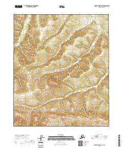
2018 Map of Charley River A-4 SE
USGS Topo · Published 2018About this map
The Yukon-Charley Rivers National Preserve encompasses most of this sub-arctic landscape, providing a detailed record of the interior drainage systems before significant human development. Rising in the northwest, the Mertie Mountains overlook a network of alpine streams that feed the regional hydrology. The topography is defined by the winding paths of Fisher Cr, Flat Cr, and Maud Cr, which carve through the high-elevation terrain of the Southeast Fairbanks Census Area. The absence of roads or permanent settlements in this 2018 survey emphasizes the isolation of this wilderness block. Instead, researchers and geographers find a pristine view of the sub-arctic watershed, including the headwaters of Derwent Cr and Research Cr. The map preserves the complex contours and natural boundaries of this protected Alaskan corridor during the early 21st century.
Find a feature on this map
12 named features on this map. Tap any name to fly to it.
Don’t see what you’re looking for? This feature index may not catch every label — zoom into the map to look around manually.
Map Details
Editions of this 2018 Charley River A-4 SE Map
This is the sole edition of this map. No revisions or reprints were ever made.
Other maps of this area

1951 · Charley River
USGS Topo · 1:250,000

1951 · Eagle
USGS Topo · 1:250,000

1956 · Charley River A-4
USGS Topo · 1:63,360

1956 · Charley River A-3
USGS Topo · 1:63,360

1956 · Charley River
USGS Topo · 1:250,000

1956 · Eagle D-3
USGS Topo · 1:63,360
1956 · Eagle D-4
USGS Topo · 1:63,360

1957 · Eagle
USGS Topo · 1:250,000
2018 · Eagle D-4 NW
USGS Topo · 1:25,000
2018 · Charley River A-4 NE
USGS Topo · 1:25,000