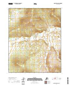
2018 Map of Charley River D-2 NW
USGS Topo · Published 2018About this map
The Wood River winds through this expanse of the Yukon-Koyukuk region, its serpentine path cutting through a landscape defined by dramatic elevation changes. The waterway meanders across the central and northern sections of the map, serving as the primary geographical focal point in a territory otherwise marked by its lack of established settlements or human infrastructure. Detailed contour lines provided by the U.S. Geological Survey illustrate the steep ridges and drainages that feed into the river basin, providing a clear picture of the hydrological patterns in this interior Alaskan wilderness.
Find a feature on this map
8 named features on this map. Tap any name to fly to it.
Don’t see what you’re looking for? This feature index may not catch every label — zoom into the map to look around manually.
Map Details
Editions of this 2018 Charley River D-2 NW Map
This is the sole edition of this map. No revisions or reprints were ever made.
Other maps of this area

1951 · Charley River
USGS Topo · 1:250,000

1951 · Black River
USGS Topo · 1:250,000

1956 · Black River A-2
USGS Topo · 1:63,360

1956 · Black River A-3
USGS Topo · 1:63,360

1956 · Charley River D-3
USGS Topo · 1:63,360

1956 · Black River
USGS Topo · 1:250,000

1956 · Charley River D-2
USGS Topo · 1:63,360

1956 · Charley River
USGS Topo · 1:250,000

1964 · Black River
USGS Topo · 1:250,000
2018 · Black River A-3 SE
USGS Topo · 1:25,000