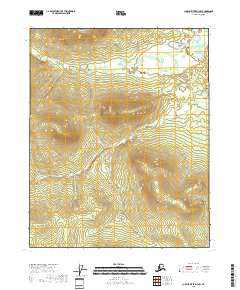
2018 Map of Charley River D-3 NW
USGS Topo · Published 2018About this map
Fanny Mtn anchors the northern reaches of this interior Alaska landscape, where the high country drops toward the drainage of Bear Mountain Cr. The terrain is characterized by a series of high ridges and deep valleys, captured here as they appeared in 2018 during a modern U.S. Geological Survey study. The area is defined largely by its hydrological and topographical features rather than human settlement, showing the drainage patterns through townships t14n r25e and t13n r25e. This survey provides a precise look at the elevation and natural contours of the Yukon-Koyukuk region, reflecting the unpopulated and undeveloped state of the Alaskan interior in the early twenty-first century.
Find a feature on this map
8 named features on this map. Tap any name to fly to it.
Don’t see what you’re looking for? This feature index may not catch every label — zoom into the map to look around manually.
Map Details
Editions of this 2018 Charley River D-3 NW Map
This is the sole edition of this map. No revisions or reprints were ever made.
Other maps of this area

1951 · Charley River
USGS Topo · 1:250,000

1951 · Black River
USGS Topo · 1:250,000

1956 · Black River A-4
USGS Topo · 1:63,360

1956 · Black River A-3
USGS Topo · 1:63,360
1956 · Charley River D-4
USGS Topo · 1:63,360

1956 · Charley River D-3
USGS Topo · 1:63,360

1956 · Black River
USGS Topo · 1:250,000

1956 · Charley River
USGS Topo · 1:250,000

1964 · Black River
USGS Topo · 1:250,000
1984 · Black River A-4
USGS Topo · 1:63,360