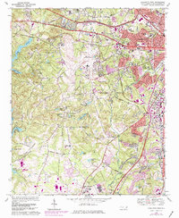
1968 Map of Charlotte West
USGS Topo · Published 1981About this map
The western edges of Charlotte expand toward the Catawba River basin on this mid-century survey, showing the transition from rural Mecklenburg County to an urbanizing transport hub. Centered on Douglas Municipal Airport, the landscape is a network of small family-named water bodies like Wait Lake and Maynard Lake, alongside established crossroads such as Dixie and Shopton. This era captures the footprint of the National Guard and the Mecklenburg Complex Dept of Correction before later industrial developments reached the banks of Lake Wylie.
Find a feature on this map
78 named features on this map. Tap any name to fly to it.
Don’t see what you’re looking for? This feature index may not catch every label — zoom into the map to look around manually.
Map Details
Editions of this 1968 Charlotte West Map
3 editions found
Other maps of this area

1905 · Charlotte
USGS Topo · 1:48,000

1907 · Charlotte
USGS Topo · 1:62,500

1914 · Gastonia
USGS Topo · 1:48,000

1916 · Gastonia
USGS Topo · 1:62,500

1941 · Charlotte
USGS Topo · 1:125,000

1942 · Charlotte
USGS Topo · 1:125,000

1947 · Clover
USGS Topo · 1:62,500

1948 · Paw Creek
USGS Topo · 1:24,000

1948 · Derita
USGS Topo · 1:24,000

1948 · Charlotte East
USGS Topo · 1:24,000