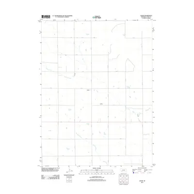
2011 Map of Chase
USGS Topo · Published 2011About this map
Chase and its surrounding agricultural landscape are defined by a strict section-line grid of rural roads and intermittent drainages. This high-plains terrain in Southwest Nebraska is characterized by the meandering path of Wildhorse Creek in the north and the Davidson Branch which cuts across the southern portion of the quadrangle. The settlement pattern here is sparse, with the Chase Cemetery serving as a significant landmark for local history and genealogical research. The map illustrates a landscape organized by numbered roads like 741 Rd and avenues such as 322 Ave, reflecting the systematic land division of the region. Scattered stock ponds and small depressions suggest a reliance on seasonal water management in this prairie environment.
Find a feature on this map
19 named features on this map. Tap any name to fly to it.
Don’t see what you’re looking for? This feature index may not catch every label — zoom into the map to look around manually.
Map Details
Editions of this 2011 Chase Map
This is the sole edition of this map. No revisions or reprints were ever made.
Other maps of this area

1954 · McCook
USGS Topo · 1:250,000

1957 · McCook
USGS Topo · 1:250,000

1958 · McCook
USGS Topo · 1:250,000

1961 · Lamar NE
USGS Topo · 1:24,000

1961 · Lamar
USGS Topo · 1:24,000

1961 · Lamar NW
USGS Topo · 1:24,000

1973 · Champion
USGS Topo · 1:24,000
1973 · Lamar
USGS Topo · 1:24,000
1973 · Chase
USGS Topo · 1:24,000

1973 · Imperial
USGS Topo · 1:24,000