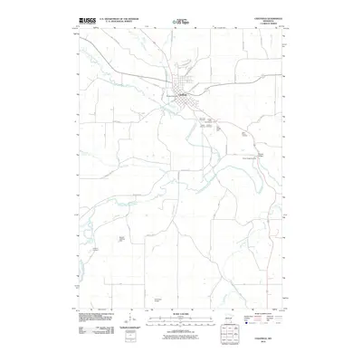
2010 Map of Chatfield
USGS Topo · Published 2010About this map
Chatfield sits at the confluence of several watercourses, most notably where Mill Creek joins the North Branch Root River. This 2010 survey reveals a community deeply connected to its river system, with the Middle Branch Root River and Bear Creek carving through the surrounding landscape. The area is marked by several significant burial grounds, including Loughrey Cemetery to the southwest and a cluster of sites like Saint Paul Cemetery and Calvary Cemetery just outside the main town. Modern land use is visible through features like the Chosen Valley Golf Course and small private infrastructure such as the Ronald Gehling Dam. The map also captures the local transportation network, highlighting family-named crossings like Parsley Bridge and the Kohlmeyer Airport at the southern edge of the quadrangle.
Find a feature on this map
42 named features on this map. Tap any name to fly to it.
Don’t see what you’re looking for? This feature index may not catch every label — zoom into the map to look around manually.
Map Details
Editions of this 2010 Chatfield Map
This is the sole edition of this map. No revisions or reprints were ever made.
Other maps of this area

1954 · Chatfield
USGS Topo · 1:62,500

1954 · Mason City
USGS Topo · 1:250,000

1955 · Stewartville
USGS Topo · 1:62,500

1957 · Mason City
USGS Topo · 1:250,000

1958 · Mason City
USGS Topo · 1:250,000

1965 · Wykoff
USGS Topo · 1:24,000

1965 · Fountain
USGS Topo · 1:24,000
1965 · Preston
USGS Topo · 1:24,000
1974 · Pilot Mound
USGS Topo · 1:24,000
1974 · Marion
USGS Topo · 1:24,000