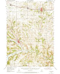
1954 Map of Chatfield
USGS Topo · Published 1973About this map
The Chicago and North Western corridor connects the rail towns of Eyota, Dover, and St. Charles in the northern portion of this 1954 study area. This landscape at the junction of Olmsted and Winona Counties is defined by a dense network of country schoolhouses, many of which were already marked as abandoned by the mid-century, such as School No 122 and Butler Sch.
Find a feature on this map
86 named features on this map. Tap any name to fly to it.
Don’t see what you’re looking for? This feature index may not catch every label — zoom into the map to look around manually.
Map Details
Editions of this 1954 Chatfield Map
2 editions found
Other maps of this area

1932 · Cochrane
USGS Topo · 1:62,500

1934 · Plainview
USGS Topo · 1:62,500

1934 · Cochrane
USGS Topo · 1:62,500

1935 · Rochester
USGS Topo · 1:48,000

1937 · Cochrane
USGS Topo · 1:62,500

1938 · Plainview
USGS Topo · 1:62,500

1939 · Rochester
USGS Topo · 1:62,500

1953 · Saint Paul
USGS Topo · 1:250,000

1953 · Eau Claire
USGS Topo · 1:250,000

1954 · Chatfield
USGS Topo · 1:62,500