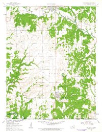
1962 Map of Chautauqua
USGS Topo · Published 1963About this map
Sedan and the surrounding township terrain are defined by the industry of the Sedan Oil Field and a network of waterways including Middle Caney Creek and Missouri Middle Creek. In the early 1960s, the landscape south toward the Oklahoma border reveals a transition from these agricultural and industrial uplands to the rising waters of the Hulah Res, where the normal pool elevation is recorded at 733 feet. The map captures critical genealogical landmarks such as Casement Cem, Greenwood Cem, and Findley Cem, alongside the remote Walter Landing Strip. A significant historical line, the Old Indian Treaty Boundary, bisects the southern half of the quadrangle, serving as a reminder of earlier territorial divisions. Transport is anchored by the Missouri Pacific railroad in the north and traces of an Old Railroad Grade further south, reflecting the area's evolving transit infrastructure.
Find a feature on this map
35 named features on this map. Tap any name to fly to it.
Don’t see what you’re looking for? This feature index may not catch every label — zoom into the map to look around manually.
Map Details
Editions of this 1962 Chautauqua Map
2 editions found
Other maps of this area

1885 · Sedan
USGS Topo · 1:125,000

1889 · Sedan
USGS Topo · 1:125,000

1909 · Pawhuska
USGS Topo · 1:125,000

1910 · Pawhuska
USGS Topo · 1:125,000

1955 · Wichita
USGS Topo · 1:250,000

1955 · Enid
USGS Topo · 1:250,000

1958 · Enid
USGS Topo · 1:250,000

1958 · Wichita
USGS Topo · 1:250,000

1962 · Sedan
USGS Topo · 1:24,000

1962 · Elgin NE
USGS Topo · 1:24,000