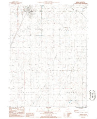
1986 Map of Chenoa
USGS Topo · Published 1986About this map
The town of Chenoa serves as the central hub of this mid-1980s landscape, positioned at a major transportation junction in rural McLean County. This survey, compiled from aerial photography taken in 1983, illustrates the geometric precision of the Illinois prairie, where agricultural fields are divided by a network of straight-line section roads and intermittent waterways. The natural drainage of the area is defined by the winding paths of Rooks Creek in the northeast and Henline Creek and Patton Creek to the south. Small rural markers like a local Cem and the infrastructure of the Sewage Disposal Pond provide specific points of interest for local history researchers. Beyond the main settlement of Chenoa, the map extends into portions of Yates, Lexington, and Lawndale townships, capturing the quiet character of the region just before modern expansion began to alter these long-established agricultural boundaries.
Find a feature on this map
12 named features on this map. Tap any name to fly to it.
Don’t see what you’re looking for? This feature index may not catch every label — zoom into the map to look around manually.
Map Details
Editions of this 1986 Chenoa Map
This is the sole edition of this map. No revisions or reprints were ever made.
Other maps of this area

1926 · Normal
USGS Topo · 1:62,500

1930 · Normal
USGS Topo · 1:62,500

1935 · Pontiac
USGS Topo · 1:62,500

1939 · Pontiac
USGS Topo · 1:62,500

1957 · Colfax
USGS Topo · 1:62,500

1958 · Flanagan
USGS Topo · 1:62,500

1958 · Peoria
USGS Topo · 1:250,000

1961 · Peoria
USGS Topo · 1:250,000

1963 · Peoria
USGS Topo · 1:250,000

1981 · Lexington
USGS Topo · 1:24,000