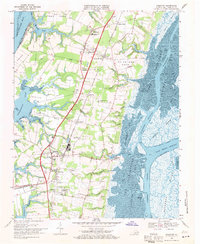
1968 Map of Cheriton
USGS Topo · Published 1971About this map
Eastville and Cheriton serve as the primary hubs for this 1968 study of the lower Delmarva Peninsula, where the Penn Central railroad corridors and U.S. 13 cut through a landscape of historic neck lands and tidal marshes. The map reveals a high density of small crossroads settlements and community centers like James Crossroads, Stumptown, and Pat Town, many of which developed around the rail line at points like Eastville Station and Parsons Siding.
Find a feature on this map
68 named features on this map. Tap any name to fly to it.
Don’t see what you’re looking for? This feature index may not catch every label — zoom into the map to look around manually.
Map Details
Editions of this 1968 Cheriton Map
3 editions found
Other maps of this area

1942 · Cheriton
USGS Topo · 1:24,000

1942 · Cobb Island
USGS Topo · 1:24,000

1942 · Nassawadox
USGS Topo · 1:24,000

1943 · Nassawadox
USGS Topo · 1:31,680

1943 · Elliots Creek
USGS Topo · 1:25,000

1943 · Townsend
USGS Topo · 1:24,000

1943 · Franktown
USGS Topo · 1:31,680

1943 · Richmond
USGS Topo · 1:250,000

1946 · Eastville
USGS Topo · 1:250,000

1948 · Cape Charles
USGS Topo · 1:24,000