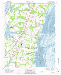
1968 Map of Cheriton
USGS Topo · Published 1981About this map
The narrow coastal landscape of the Eastern Shore of Virginia comes into focus in this late 1960s survey, defined by the Penn Central rail line running the length of the peninsula. Small agricultural and rail-dependent settlements like Eastville and Cheriton anchor the interior, while the intricate marshlands and tidal flats of Thorofare Bay and Mockhorn Bay dominate the Atlantic-facing eastern edge. The map reveals the deeply interconnected nature of the land and water, with family-named inlets such as Eyreville Creek and Spady Creek reaching inland toward crossroads like James Crossroads and Stumptown.
Find a feature on this map
75 named features on this map. Tap any name to fly to it.
Don’t see what you’re looking for? This feature index may not catch every label — zoom into the map to look around manually.
Map Details
Editions of this 1968 Cheriton Map
3 editions found
Other maps of this area

1942 · Cheriton
USGS Topo · 1:24,000

1942 · Cobb Island
USGS Topo · 1:24,000

1942 · Nassawadox
USGS Topo · 1:24,000

1943 · Nassawadox
USGS Topo · 1:31,680

1943 · Elliots Creek
USGS Topo · 1:25,000

1943 · Townsend
USGS Topo · 1:24,000

1943 · Franktown
USGS Topo · 1:31,680

1943 · Richmond
USGS Topo · 1:250,000

1946 · Eastville
USGS Topo · 1:250,000

1948 · Cape Charles
USGS Topo · 1:24,000