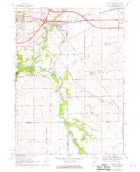
1968 Map of Cherry Valley
USGS Topo · Published 1970About this map
Cherry Valley and the surrounding borderlands of Winnebago, Boone, Ogle, and De Kalb counties are documented here in the late 1960s. The Kishwaukee River and its South Branch serve as the primary geographical anchors, winding through a landscape transitioning from suburban expansion near Rockford and Belvidere to a rural agricultural interior. Early regional transportation is evident in the path of the Chicago and North Western railroad and the Northwest Tollway, which intersect near the town center. Local history and genealogy interest is concentrated at sites like Arlington Memorial Park Cem and German Cem, while smaller settlements such as Perryville, Irene, and Trimble mark the intersections of rural routes like Flora Church Road and Cherry Valley Road. The map also captures the local extractive industry through several Gravel Pits and Quarries scattered across Flora and Monroe townships.
Find a feature on this map
52 named features on this map. Tap any name to fly to it.
Don’t see what you’re looking for? This feature index may not catch every label — zoom into the map to look around manually.
Map Details
Editions of this 1968 Cherry Valley Map
3 editions found
Other maps of this area

1917 · Kings
USGS Topo · 1:62,500

1918 · Rockford
USGS Topo · 1:62,500

1918 · Belvidere
USGS Topo · 1:62,500

1918 · Kings
USGS Topo · 1:62,500

1918 · Kirkland
USGS Topo · 1:62,500

1938 · Rockford
USGS Topo · 1:62,500

1944 · Belvidere
USGS Topo · 1:62,500

1949 · Camp Grant
USGS Topo · 1:24,000

1949 · Rockford
USGS Topo · 1:24,000

1954 · Rockford
USGS Topo · 1:250,000