
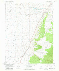
1966 Map of Chester
USGS Topo · Published 1968About this map
The Sanpete Valley is characterized by an intricate network of irrigation ditches and canals that support the agriculture of this central Utah region. The San Pitch River winds through the western half of the sheet, flanked by the Denver and Rio Grande Western railroad line. Small farming communities like Chester and West Ephraim serve as local hubs, while the map records the specific location of the Chester PO and the rail-linked Pigeon Hollow Junction.
Find a feature on this map
32 named features on this map. Tap any name to fly to it.
Don’t see what you’re looking for? This feature index may not catch every label — zoom into the map to look around manually.
Map Details
Editions of this 1966 Chester Map
2 editions found
Other maps of this area

1885 · Manti
USGS Topo · 1:250,000

1895 · Manti
USGS Topo · 1:250,000

1951 · Moroni
USGS Topo · 1:62,500

1956 · Price
USGS Topo · 1:250,000

1960 · Price
USGS Topo · 1:250,000

1962 · Price
USGS Topo · 1:250,000

1965 · Manti
USGS Topo · 1:24,000

1965 · Wales
USGS Topo · 1:24,000

1966 · Spring City
USGS Topo · 1:24,000
1966 · Ephraim
USGS Topo · 1:24,000