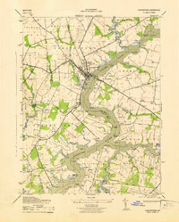
1943 Map of Chestertown
USGS Topo · Published 1943About this map
The Chestertown riverfront and the academic grounds of Washington College define this 1940s landscape along the winding Chester River. As a wartime era survey by the Army Corps of Engineers, it captures the critical transition between the old maritime economy and modern inland transport. The Pennsylvania Chestertown Branch railroad cuts across the agricultural interior, serving small communities like Pomona and Old Town. A dense network of landings and wharves, such as Riverside Wharf and Buckingham Wharf, still line the riverbanks and creeks like Southeast Creek, illustrating how deep-water access remained vital for Kent County commerce. Genealogists can locate smaller rural landmarks including Bond Chapel, Union Church, and Reid Hall School, along with family-named points like Wilmer Pt and Fryingpan Pt that mark the jagged shoreline of the Devils Reach.
Find a feature on this map
82 named features on this map. Tap any name to fly to it.
Don’t see what you’re looking for? This feature index may not catch every label — zoom into the map to look around manually.
Map Details
Editions of this 1943 Chestertown Map
This is the sole edition of this map. No revisions or reprints were ever made.
Other maps of this area

1898 · Tolchester
USGS Topo · 1:125,000

1899 · Dover
USGS Topo · 1:125,000

1900 · Cecilton
USGS Topo · 1:62,500

1900 · Betterton
USGS Topo · 1:62,500

1901 · Chestertown
USGS Topo · 1:62,500

1903 · Tolchester
USGS Topo · 1:125,000

1905 · Barclay
USGS Topo · 1:62,500

1906 · Dover
USGS Topo · 1:125,000

1908 · Tolchester
USGS Topo · 1:125,000

1920 · Dover
USGS Topo · 1:125,000