
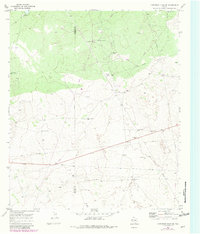
1970 Map of Cheyenne Draw SE
USGS Topo · Published 1973About this map
Isolated livestock ranching and petroleum infrastructure define this pocket of the West Texas Permian Basin. Private holdings like Haley Ranch, Yantis Ranch, and Willow Wells Ranch are scattered across a landscape where water is the primary concern, evidenced by the numerous named water-pumping landmarks such as the Lehman Windmill, Parker Windmill, and Beacon Windmill.
Find a feature on this map
17 named features on this map. Tap any name to fly to it.
Don’t see what you’re looking for? This feature index may not catch every label — zoom into the map to look around manually.
Map Details
Editions of this 1970 Cheyenne Draw SE Map
2 editions found
Other maps of this area

1954 · Pecos
USGS Topo · 1:250,000

1957 · Pecos
USGS Topo · 1:250,000

1967 · Soda Lake NW
USGS Topo · 1:24,000

1968 · Wink South
USGS Topo · 1:24,000

1968 · Soda Lake NE
USGS Topo · 1:24,000

1969 · Cheyenne Draw SW
USGS Topo · 1:24,000

1970 · Brunson Ranch
USGS Topo · 1:24,000

1970 · Cheyenne Draw
USGS Topo · 1:24,000

1970 · Wink North
USGS Topo · 1:24,000

1970 · Kermit NW
USGS Topo · 1:24,000