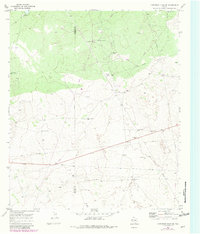
1970 Map of Cheyenne Draw SE
USGS Topo · Published 1981About this map
Haas Ranch and Yantis Ranch occupy this West Texas landscape near the border of Loving and Winkler Counties. In this semi-arid region, the network of water sources is vital for land use, evidenced by named features such as Lehman Windmill, Twin Windmills, and Parker Windmill. The terrain is also defined by industrial development, including a central Pumping Sta, numerous Gas Wells, and several Drill Holes.
Find a feature on this map
25 named features on this map. Tap any name to fly to it.
Don’t see what you’re looking for? This feature index may not catch every label — zoom into the map to look around manually.
Map Details
Editions of this 1970 Cheyenne Draw SE Map
2 editions found
Other maps of this area

1954 · Pecos
USGS Topo · 1:250,000

1957 · Pecos
USGS Topo · 1:250,000

1967 · Soda Lake NW
USGS Topo · 1:24,000

1968 · Wink South
USGS Topo · 1:24,000

1968 · Soda Lake NE
USGS Topo · 1:24,000

1969 · Cheyenne Draw SW
USGS Topo · 1:24,000

1970 · Brunson Ranch
USGS Topo · 1:24,000

1970 · Cheyenne Draw
USGS Topo · 1:24,000

1970 · Wink North
USGS Topo · 1:24,000

1970 · Cheyenne Draw SE
USGS Topo · 1:24,000