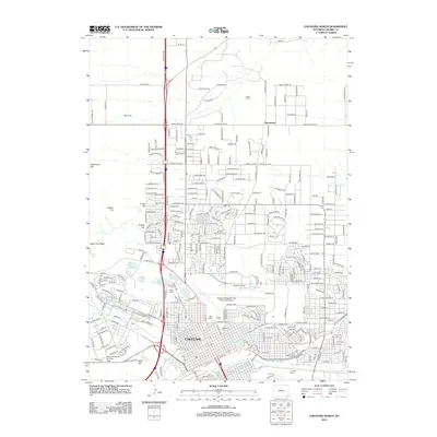
2012 Map of Cheyenne North
USGS Topo · Published 2012About this map
Cheyenne serves as the focal point of this 2012 survey, revealing the northern expansion of Wyoming’s capital city into the High Plains. The landscape is a mix of dense urban grids and more open residential developments like Ranchettes. Vital infrastructure and military presence are prominent, notably the Francis E Warren Air Force Base in the southwest and the Cheyenne Regional/Jerry Olson Field Airport near the center. The city's recreation and water management are visible through a chain of lakes including Sloan Lake, Kiwanis Lake, and Lake Minnehaha. For genealogists and local historians, the map identifies significant burial grounds such as Beth El Cem and Olivet Cem. The influence of the frontier remains through landmarks like Frontier Park and the rugged topography of Stevenson Hill and Bell Corral, while the modern transportation corridor of the I-25 Service Rd dictates the region's current growth pattern.
Find a feature on this map
273 named features on this map. Tap any name to fly to it.
Don’t see what you’re looking for? This feature index may not catch every label — zoom into the map to look around manually.
Map Details
Editions of this 2012 Cheyenne North Map
This is the sole edition of this map. No revisions or reprints were ever made.
Other maps of this area

1911 · Cheyenne
USGS Topo · 1:125,000

1914 · Cheyenne
USGS Topo · 1:125,000

1950 · Cheyenne
USGS Topo · 1:62,500

1954 · Cheyenne
USGS Topo · 1:250,000

1958 · Cheyenne
USGS Topo · 1:250,000

1961 · Round Top Lake
USGS Topo · 1:24,000

1961 · Cheyenne South
USGS Topo · 1:24,000
1961 · Borie
USGS Topo · 1:24,000

1961 · Cheyenne
USGS Topo · 1:62,500

1961 · Cheyenne North
USGS Topo · 1:24,000