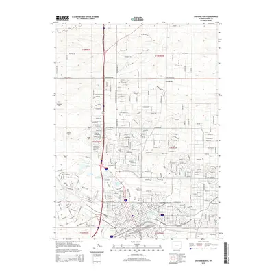
2015 Map of Cheyenne North
USGS Topo · Published 2015About this map
Cheyenne expands northward into the high plains in this modern survey, where urban infrastructure meets the traditional western landscape. The city’s northern fringe is characterized by residential development in Ranchettes and significant recreational and institutional land use, including Kiwanis Lake, Sloan Lake, and the College of America - Cheyenne. A cluster of historic burial grounds, including Beth El Cem, Olivet Cem, and Lakeview Cem, marks the transition from the city core to the newer outskirts. The area’s geography is defined by a series of prominent rises such as Augur Hill, Gilbert Hill, and Dodge Hill, which overlook the busy corridors of the Burlington Northern Santa Fe and Union Pacific railroads. The industrial and transportation legacy of the region is further anchored by the Cheyenne Regional Airport/Jerry Olson Field, formerly the historic airfield serving this capital city.
Find a feature on this map
61 named features on this map. Tap any name to fly to it.
Don’t see what you’re looking for? This feature index may not catch every label — zoom into the map to look around manually.
Map Details
Editions of this 2015 Cheyenne North Map
This is the sole edition of this map. No revisions or reprints were ever made.
Other maps of this area

1911 · Cheyenne
USGS Topo · 1:125,000

1914 · Cheyenne
USGS Topo · 1:125,000

1950 · Cheyenne
USGS Topo · 1:62,500

1954 · Cheyenne
USGS Topo · 1:250,000

1958 · Cheyenne
USGS Topo · 1:250,000

1961 · Round Top Lake
USGS Topo · 1:24,000

1961 · Cheyenne South
USGS Topo · 1:24,000
1961 · Borie
USGS Topo · 1:24,000

1961 · Cheyenne
USGS Topo · 1:62,500

1961 · Cheyenne North
USGS Topo · 1:24,000