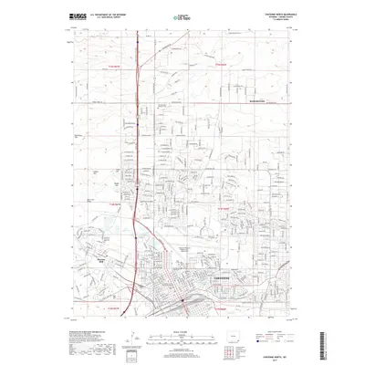
2017 Map of Cheyenne North
USGS Topo · Published 2017About this map
Cheyenne and its northern suburbs are defined by a complex intersection of military history, aviation, and water management. The expansive grounds of Warren AFB dominate the western portion of the city, where the Frances E Warren Air Base Cem sits near Diamond Creek. This area is notable for its high concentration of local heritage sites, including the Saint Mary's Catholic Church Columbarium and a cluster of historic burial grounds such as Beth El Cem, Odd Fellows Cem, and Mount Sinai Jewish Cem.
Find a feature on this map
227 named features on this map. Tap any name to fly to it.
Don’t see what you’re looking for? This feature index may not catch every label — zoom into the map to look around manually.
Map Details
Editions of this 2017 Cheyenne North Map
This is the sole edition of this map. No revisions or reprints were ever made.
Other maps of this area

1911 · Cheyenne
USGS Topo · 1:125,000

1914 · Cheyenne
USGS Topo · 1:125,000

1950 · Cheyenne
USGS Topo · 1:62,500

1954 · Cheyenne
USGS Topo · 1:250,000

1958 · Cheyenne
USGS Topo · 1:250,000

1961 · Round Top Lake
USGS Topo · 1:24,000

1961 · Cheyenne South
USGS Topo · 1:24,000
1961 · Borie
USGS Topo · 1:24,000

1961 · Cheyenne
USGS Topo · 1:62,500

1961 · Cheyenne North
USGS Topo · 1:24,000