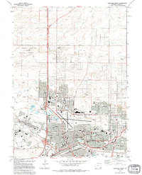
1994 Map of Cheyenne North
USGS Topo · Published 1994About this map
Francis E Warren Air Force Base dominates the western portion of this 1990s-era landscape, showing the military footprint just north of the state capital. The urban grid of Cheyenne extends northward, characterized by a dense network of public institutions including the Veterans Administration Hospital and numerous schools like Central High Sch and McCormick Jr High Sch. Recreational and civic spaces are prominent, most notably the Frontier Park (Rodeo Ground), home to the city's famed western heritage events.
Find a feature on this map
61 named features on this map. Tap any name to fly to it.
Don’t see what you’re looking for? This feature index may not catch every label — zoom into the map to look around manually.
Map Details
Editions of this 1994 Cheyenne North Map
This is the sole edition of this map. No revisions or reprints were ever made.
Other maps of this area

1911 · Cheyenne
USGS Topo · 1:125,000

1914 · Cheyenne
USGS Topo · 1:125,000

1950 · Cheyenne
USGS Topo · 1:62,500

1954 · Cheyenne
USGS Topo · 1:250,000

1958 · Cheyenne
USGS Topo · 1:250,000

1961 · Round Top Lake
USGS Topo · 1:24,000

1961 · Cheyenne South
USGS Topo · 1:24,000
1961 · Borie
USGS Topo · 1:24,000

1961 · Cheyenne
USGS Topo · 1:62,500

1961 · Cheyenne North
USGS Topo · 1:24,000