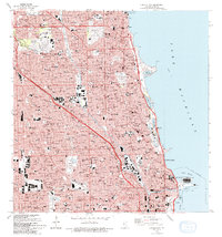
1993 Map of Chicago Loop
USGS Topo · Published 1993About this map
The North Branch Chicago River and the North Branch Canal carve through the urban landscape of northern Chicago, framing the industrial and residential development of the early 1990s. This survey details the dense concentration of civic and cultural institutions that anchor the city, from the Merchandise Mart and Chicago City Hall in the Chicago Loop to the sprawling grounds of Rosehill Cemetery and Graceland Cemetery. Along the shoreline of Lake Michigan, the map documents the sophisticated park and harbor system, including Grant Park, Belmont Harbor, and the South Lagoon. Significant educational landmarks like De Paul University and Northeastern Ill University appear alongside established neighborhoods such as Logan Square and Ravenswood Manor. The intricate web of the Chicago and North Western railroad and major arteries like the Kennedy Expressway illustrate the transportation network sustaining this metropolitan hub.
Find a feature on this map
76 named features on this map. Tap any name to fly to it.
Don’t see what you’re looking for? This feature index may not catch every label — zoom into the map to look around manually.
Map Details
Editions of this 1993 Chicago Loop Map
2 editions found
Other maps of this area

1889 · Chicago
USGS Topo · 1:62,500

1891 · Chicago
USGS Topo · 1:62,500

1891 · Riverside
USGS Topo · 1:62,500

1893 · Riverside
USGS Topo · 1:62,500

1899 · Evanston
USGS Topo · 1:62,500

1900 · Chicago
USGS Topo · 1:62,500

1900 · Riverside
USGS Topo · 1:62,500

1900 · Highwood
USGS Topo · 1:62,500

1901 · Riverside
USGS Topo · 1:62,500

1901 · Chicago
USGS Topo · 1:62,500
Featured Places
- Chicago, IL
- Lincolnwood, IL
- Lake View Township, Chicago
- West Chicago Township, Chicago
- Jefferson Township, Chicago