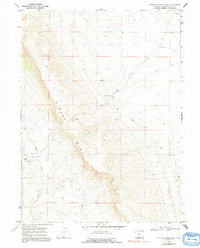
1968 Map of Chicken Creek East
USGS Topo · Published 1992About this map
The Kinney Rim dominates this high-desert landscape in Sweetwater County, creating a sharp topographical divide across the terrain. At the base of the escarpment, the transient waters of Alkali Creek and Chicken Creek drain the western slopes, where Davis Cabins stands as one of the few named structures in this expansive rangeland. This 1968 survey reveals a land managed for grazing and resource exploration, evidenced by scattered Springs such as Carson Spring and a solitary Corral located near the southern boundary. The presence of numerous Drill Hole markers throughout the quadrangle highlights the mid-century industrial interest in the geological potential of the area's subterranean layers, even as the surface remained dedicated to traditional western land use.
Find a feature on this map
9 named features on this map. Tap any name to fly to it.
Don’t see what you’re looking for? This feature index may not catch every label — zoom into the map to look around manually.
Map Details
Editions of this 1968 Chicken Creek East Map
2 editions found
Other maps of this area

1954 · Rock Springs
USGS Topo · 1:250,000

1958 · Rock Springs
USGS Topo · 1:250,000

1962 · Rock Springs
USGS Topo · 1:250,000

1968 · Chicken Creek East
USGS Topo · 1:24,000
1968 · Chicken Creek SW
USGS Topo · 1:24,000

1968 · Pine Butte
USGS Topo · 1:24,000

1968 · Sand Butte Rim SE
USGS Topo · 1:24,000
1968 · Chicken Creek SE
USGS Topo · 1:24,000
1968 · Chicken Creek West
USGS Topo · 1:24,000

1970 · Cow Creek Reservoir
USGS Topo · 1:24,000