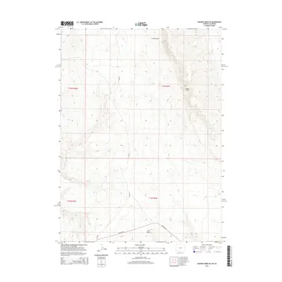
2015 Map of Chicken Creek SE
USGS Topo · Published 2015About this map
Kinney Rim dominates the northeastern landscape of this high desert region in Sweetwater County, marking a significant topographical break in an area defined by its arid drainage systems. The map details the complex natural hydrology of the Great Divide Basin, where seasonal watercourses like Crooked Wash and Alkali Cr carve through the terrain. In the southern portion of the quadrangle, the deep incision of Hells Canyon provides a stark contrast to the surrounding high plains. Evidence of modern infrastructure is sparse, primarily represented by the path of Hiawatha Rd, which traverses the southern townships. This survey serves as a precise record of the public land survey system, illustrating the grid of townships and ranges that overlay this remote section of the Wyoming-Colorado borderlands.
Find a feature on this map
45 named features on this map. Tap any name to fly to it.
Don’t see what you’re looking for? This feature index may not catch every label — zoom into the map to look around manually.
Map Details
Editions of this 2015 Chicken Creek SE Map
This is the sole edition of this map. No revisions or reprints were ever made.
Other maps of this area

1954 · Vernal
USGS Topo · 1:250,000

1954 · Rock Springs
USGS Topo · 1:250,000

1958 · Vernal
USGS Topo · 1:250,000

1958 · Rock Springs
USGS Topo · 1:250,000

1960 · Vernal
USGS Topo · 1:250,000

1962 · Rock Springs
USGS Topo · 1:250,000

1966 · Sugarloaf Butte
USGS Topo · 1:24,000

1966 · Hiawatha
USGS Topo · 1:24,000

1968 · Chicken Creek East
USGS Topo · 1:24,000
1968 · Chicken Creek SW
USGS Topo · 1:24,000