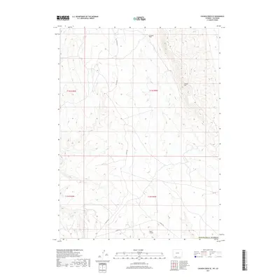
2017 Map of Chicken Creek SE
USGS Topo · Published 2017About this map
The high desert terrain of southern Sweetwater County is defined here by the prominent Kinney Rim, which creates a significant topographical divide across the northeastern portion of the sheet. Drainage patterns are dominated by the intermittent flows of Crooked Wash and Alkali Cr, carving into the arid landscape south of the Wyoming-Colorado border. This 2017 survey reveals the limited human footprint in this corner of the state, primarily consisting of remote infrastructure like Hiawatha Rd and BLM Rd 4407. The map detail is particularly useful for visualizing the stark relief of Hells Canyon in the south, illustrating the erosion-driven geography that characterizes this section of the Red Desert region near the Colorado line.
Find a feature on this map
11 named features on this map. Tap any name to fly to it.
Don’t see what you’re looking for? This feature index may not catch every label — zoom into the map to look around manually.
Map Details
Editions of this 2017 Chicken Creek SE Map
This is the sole edition of this map. No revisions or reprints were ever made.
Other maps of this area

1954 · Vernal
USGS Topo · 1:250,000

1954 · Rock Springs
USGS Topo · 1:250,000

1958 · Vernal
USGS Topo · 1:250,000

1958 · Rock Springs
USGS Topo · 1:250,000

1960 · Vernal
USGS Topo · 1:250,000

1962 · Rock Springs
USGS Topo · 1:250,000

1966 · Sugarloaf Butte
USGS Topo · 1:24,000

1966 · Hiawatha
USGS Topo · 1:24,000

1968 · Chicken Creek East
USGS Topo · 1:24,000
1968 · Chicken Creek SW
USGS Topo · 1:24,000