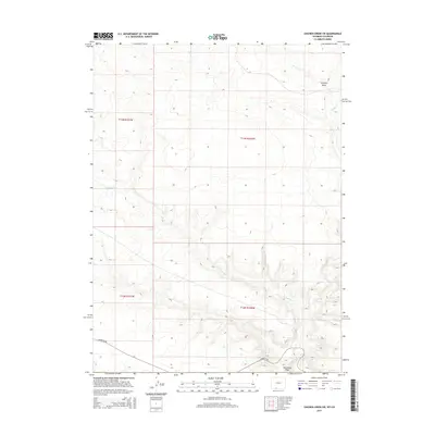
2015 Map of Chicken Creek SW
USGS Topo · Published 2015About this map
Vermillion Cr and its tributaries carve through the arid high-desert landscape of Sweetwater County in this 2015 survey. The terrain is defined by dry drainage features including Granary Draw in the northeast and Horseshoe Wash to the south. This area is largely characterized by expansive public land surveyed into sections, with Hiawatha Rd providing one of the few primary access routes through the southern portion of the quadrangle. The map captures the subtle hydrography of the region, where ephemeral flows like Alkali Cr join the larger Vermillion system, reflecting a landscape shaped by intermittent water and high-altitude desert ecology.
Find a feature on this map
9 named features on this map. Tap any name to fly to it.
Don’t see what you’re looking for? This feature index may not catch every label — zoom into the map to look around manually.
Map Details
Editions of this 2015 Chicken Creek SW Map
This is the sole edition of this map. No revisions or reprints were ever made.
Other maps of this area

1954 · Vernal
USGS Topo · 1:250,000

1954 · Rock Springs
USGS Topo · 1:250,000

1958 · Vernal
USGS Topo · 1:250,000

1958 · Rock Springs
USGS Topo · 1:250,000

1960 · Vernal
USGS Topo · 1:250,000

1962 · Rock Springs
USGS Topo · 1:250,000

1963 · Erickson-Kent Ranch
USGS Topo · 1:24,000

1963 · Scrivner Butte
USGS Topo · 1:24,000

1966 · Sugarloaf Butte
USGS Topo · 1:24,000
1966 · Sparks
USGS Topo · 1:24,000