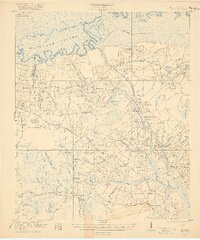
1921 Map of Chicora
USGS Topo · Published 1921About this map
The Francis Marion Tomb lies near the southern edge of the Santee River lowlands, anchoring a landscape defined by complex water management and early South Carolina transport history. Surveyed just after the Great War, this area showcases the Santee Canal (Abandoned) and the Sinkler Dam, remnants of efforts to navigate the cypress swamps and river bends of Black Oak Island. Small rural settlements like Eadytown and Chicora are surrounded by a dense network of community infrastructure, including the St Pauls Church and numerous schoolhouses such as Redeemer School and Pineville School. The terrain is characterized by numerous bays and swamps, from Bulltown Bay to Margate Swamp, which dictated the winding paths of the Sandridge and Moncks Corner Road.
Find a feature on this map
98 named features on this map. Tap any name to fly to it.
Don’t see what you’re looking for? This feature index may not catch every label — zoom into the map to look around manually.
Map Details
Editions of this 1921 Chicora Map
4 editions found
Other maps of this area

1919 · Summerville
USGS Topo · 1:48,000

1919 · Ridgeville
USGS Topo · 1:48,000

1919 · Cordesville
USGS Topo · 1:48,000

1920 · Eutawville
USGS Topo · 1:48,000

1920 · Chicora
USGS Topo · 1:48,000

1920 · Manning
USGS Topo · 1:48,000

1920 · Ridgeville
USGS Topo · 1:62,500

1920 · Summerville
USGS Topo · 1:62,500

1921 · Chicora
USGS Topo · 1:62,500

1921 · Manning
USGS Topo · 1:62,500