1921 Map of Chicora
USGS Topo · Published 1942About this map
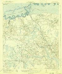
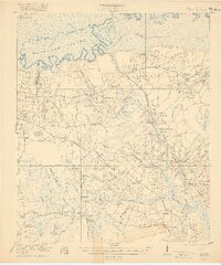
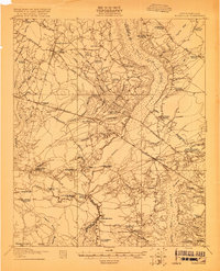
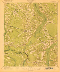
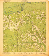
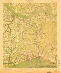
The Francis Marion Tomb lies north of the Santee Canal (Abandoned), anchoring a Berkeley County landscape defined by the winding Santee River and a complex network of swamps and bays. This 1919-1920 survey captures the region before the creation of modern reservoirs, showing a high density of rural institutions such as the Redeemer School, St Lukes Church, and the Oakland Club. The interior is dotted with distinct topographical "bays," including Bulltown Bay and Pigeon Bay, which dictated the layout of early roads like the Congaree Road. Small settlements like Eadytown, Ferguson, and Ophir are clearly mapped alongside river-dependent sites like Wilson Landing, reflecting an era of transition for the Lowcountry's hydraulic landscape and agricultural community.
Find a feature on this map
91 named features on this map. Tap any name to fly to it.
Don’t see what you’re looking for? This feature index may not catch every label — zoom into the map to look around manually.
Map Details
Editions of this 1921 Chicora Map
4 editions found

Other maps of this area

1919 · Summerville
USGS Topo · 1:48,000
1919 · Ridgeville
USGS Topo · 1:48,000

1919 · Cordesville
USGS Topo · 1:48,000

1920 · Eutawville
USGS Topo · 1:48,000

1920 · Chicora
USGS Topo · 1:48,000

1920 · Manning
USGS Topo · 1:48,000
1920 · Ridgeville
USGS Topo · 1:62,500

1920 · Summerville
USGS Topo · 1:62,500
1921 · Chicora
USGS Topo · 1:62,500
1921 · Manning
USGS Topo · 1:62,500