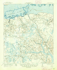
1921 Map of Chicora
USGS Topo · Published 1947About this map
Francis Marion Tomb serves as a prominent landmark in this low-country landscape, situated within a dense network of swamps and bayous north of Chicora. This 1919-1920 survey captures the region just before the mid-century hydroelectric projects fundamentally altered the hydrology of the Santee River basin. The area is characterized by an intricate drainage system including Moss Grove Swamp, Greenland Swamp, and Moultrie Swamp, which dictated the location of early settlements like Eadytown and Ferguson.
Find a feature on this map
86 named features on this map. Tap any name to fly to it.
Don’t see what you’re looking for? This feature index may not catch every label — zoom into the map to look around manually.
Map Details
Editions of this 1921 Chicora Map
4 editions found
Other maps of this area

1919 · Summerville
USGS Topo · 1:48,000

1919 · Ridgeville
USGS Topo · 1:48,000

1919 · Cordesville
USGS Topo · 1:48,000

1920 · Eutawville
USGS Topo · 1:48,000

1920 · Chicora
USGS Topo · 1:48,000

1920 · Manning
USGS Topo · 1:48,000

1920 · Ridgeville
USGS Topo · 1:62,500

1920 · Summerville
USGS Topo · 1:62,500

1921 · Chicora
USGS Topo · 1:62,500

1921 · Manning
USGS Topo · 1:62,500