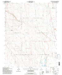
1994 Map of Chidago Canyon
USGS Topo · Published 1997About this map
Fish Slough dominates the eastern basin of this high-desert landscape, a critical riparian corridor bordered by the massive Volcanic Tableland. The terrain is defined by dramatic elevation shifts where the volcanic plateau drops into the Chalfant Valley and Hammil Valley. Evidence of human utility and settlement is sparse but significant, including the Aqueduct in the northeast and isolated sites like Milner 2 and various Gravel Pits.
Find a feature on this map
41 named features on this map. Tap any name to fly to it.
Don’t see what you’re looking for? This feature index may not catch every label — zoom into the map to look around manually.
Map Details
Editions of this 1994 Chidago Canyon Map
2 editions found
Other maps of this area

1912 · Mt. Goddard
USGS Topo · 1:125,000

1913 · Bishop
USGS Topo · 1:125,000

1914 · Mt. Morrison
USGS Topo · 1:125,000

1917 · White Mountain
USGS Topo · 1:125,000

1947 · Mariposa
USGS Topo · 1:250,000

1948 · Mariposa
USGS Topo · 1:250,000

1949 · Mt. Tom
USGS Topo · 1:62,500

1949 · Bishop
USGS Topo · 1:62,500

1951 · Mt. Tom
USGS Topo · 1:62,500

1951 · Bishop
USGS Topo · 1:62,500