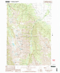
1990 Map of Chief Joseph Mtn
USGS Topo · Published 1990About this map
The Wallowa National Forest dominates this topographic study, where the high alpine terrain of the Eagle Cap Wilderness meets the agricultural fringes of the valley. Industrial history is etched into the steep slopes above Hurricane Creek, marked by the high-elevation Legore Mine and the Joseph Mtn Mines near Miners Basin. These sites reflect the era's mining activity within the high peaks of the Hurricane Divide, where access was often limited to narrow trails through landmarks like Slick Rock. In the lower elevations, the presence of the Hurricane Grange and the Joseph Cem indicates the social and civic center of the local ranching and farming community. A complex network of water management is visible through features like the Moonshine Ditch, which redirected natural flows from the mountains to support valley life, while numerous high-altitude basins hold remote waters such as Deadman Lake and Echo Lake.
Find a feature on this map
39 named features on this map. Tap any name to fly to it.
Don’t see what you’re looking for? This feature index may not catch every label — zoom into the map to look around manually.
Map Details
Editions of this 1990 Chief Joseph Mtn Map
3 editions found
Other maps of this area

1954 · Cornucopia
USGS Topo · 1:62,500

1954 · Eagle Cap
USGS Topo · 1:62,500

1955 · Grangeville
USGS Topo · 1:250,000

1957 · Enterprise
USGS Topo · 1:62,500

1957 · Joseph
USGS Topo · 1:62,500

1959 · Grangeville
USGS Topo · 1:250,000

1986 · Enterprise
USGS Topo · 1:100,000

1990 · Lostine
USGS Topo · 1:24,000

1990 · Chief Joseph Mtn
USGS Topo · 1:24,000
1990 · Eagle Cap
USGS Topo · 1:24,000