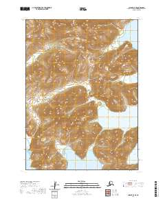
2020 Map of Chignik A-3 SE
USGS Topo · Published 2020About this map
The Aleutian Range dominates this coastal landscape on the Alaska Peninsula, where steep topographic gradients drop sharply into the North Pacific. This 2020 survey records a transition from high mountain ridges to the protected waters of several distinct inlets. Windy Bay and Foot Bay pierce the eastern coastline, while Fishrack Bay and Fishhook Bay define the southern maritime boundary. The map illustrates a wilderness shaped by extreme relief and water, highlighting the natural harbors that characterize the Lake and Peninsula Borough. The absence of roads or permanent settlements underscores the isolation of this terrain, where the primary features are the interactions between the glacial-carved mountains and the sea.
Find a feature on this map
9 named features on this map. Tap any name to fly to it.
Don’t see what you’re looking for? This feature index may not catch every label — zoom into the map to look around manually.
Map Details
Editions of this 2020 Chignik A-3 SE Map
This is the sole edition of this map. No revisions or reprints were ever made.
Other maps of this area

1951 · Stepovak Bay
USGS Topo · 1:250,000

1963 · Stepovak Bay D-2
USGS Topo · 1:63,360

1963 · Chignik A-2
USGS Topo · 1:63,360

1963 · Chignik A-3
USGS Topo · 1:63,360

1963 · Chignik
USGS Topo · 1:250,000
1963 · Stepovak Bay D-3
USGS Topo · 1:63,360

1963 · Stepovak Bay
USGS Topo · 1:250,000

1969 · Stepovak Bay
USGS Topo · 1:250,000
2020 · Stepovak Bay D-2 NW
USGS Topo · 1:25,000
2020 · Chignik A-3 SW
USGS Topo · 1:25,000