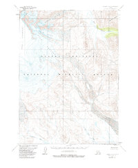
1963 Map of Chignik A-4
USGS Topo · Published 1985About this map
Mount Veniaminof dominates this portion of the Alaska Peninsula, its massive ice-covered slopes feeding a system of radiating glaciers. This 1963 survey, revised in the early 1980s, captures the high-altitude terrain of the Alaska Peninsula National Wildlife Refuge. From the northern ice fields of Finger Glacier, Harpoon Glacier, and Slim Glacier, meltwater carves through the landscape to feed the headwaters of several coastal drainage systems. The West Fork Chignik River flows through the northeast, while the Kametolook River and Red Bluff Creek drain the southern slopes toward the Pacific. The absence of roads or permanent settlements emphasizes the wilderness character of the region, where topographical features like Bearskin Gulch and Crob Glacier serve as the primary landmarks for navigation and land management by the Bureau of Land Management and Geological Survey.
Find a feature on this map
10 named features on this map. Tap any name to fly to it.
Don’t see what you’re looking for? This feature index may not catch every label — zoom into the map to look around manually.
Map Details
Editions of this 1963 Chignik A-4 Map
3 editions found
Other maps of this area

1951 · Stepovak Bay
USGS Topo · 1:250,000

1963 · Chignik A-4
USGS Topo · 1:63,360

1963 · Stepovak Bay D-4
USGS Topo · 1:63,360

1963 · Chignik B-5
USGS Topo · 1:63,360

1963 · Chignik B-4
USGS Topo · 1:63,360

1963 · Chignik A-5
USGS Topo · 1:63,360

1963 · Chignik A-3
USGS Topo · 1:63,360

1963 · Chignik B-3
USGS Topo · 1:63,360

1963 · Stepovak Bay D-5
USGS Topo · 1:63,360

1963 · Chignik
USGS Topo · 1:250,000