
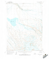
1963 Map of Chignik A-6
USGS Topo · Published 1967About this map
Sandy Lake dominates the western portion of this 1963 Alaskan survey, serving as the headwater for the Sandy River as it winds toward the east. This landscape, captured through aerial photography from 1957 and 1962, reflects the drainage patterns of the Aleutians East region. The Muddy River flows through the northern reaches of the quadrangle, while the southern terrain is defined by the course of the Milky River. The map provides a clear look at the glacial and volcanic topography of the area during the early 1960s, prior to significant modern development. Land lines on this sheet represent unsurveyed locations predetermined by the Bureau of Land Management, highlighting the remote and wild nature of the territory at the time of the field annotation.
Find a feature on this map
4 named features on this map. Tap any name to fly to it.
Don’t see what you’re looking for? This feature index may not catch every label — zoom into the map to look around manually.
Map Details
Editions of this 1963 Chignik A-6 Map
2 editions found
Other maps of this area

1951 · Stepovak Bay
USGS Topo · 1:250,000

1953 · Port Moller
USGS Topo · 1:250,000
1963 · Chignik B-7
USGS Topo · 1:63,360

1963 · Chignik B-5
USGS Topo · 1:63,360

1963 · Chignik B-6
USGS Topo · 1:63,360

1963 · Chignik A-5
USGS Topo · 1:63,360

1963 · Chignik A-7
USGS Topo · 1:63,360

1963 · Stepovak Bay D-6
USGS Topo · 1:63,360

1963 · Stepovak Bay D-5
USGS Topo · 1:63,360

1963 · Chignik
USGS Topo · 1:250,000