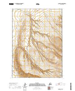
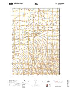
2020 Map of Chignik D-2 NE
USGS Topo · Published 2020About this map
The Alaska Peninsula National Wildlife Refuge dominates the southeastern quadrant of this terrain, showcasing a protected landscape defined by complex hydrology and significant elevation changes. The drainage patterns of Reindeer Creek and Barabara Creek illustrate the natural flow of the peninsula, with the former cutting a winding path through the northern and eastern sections. A small portion of the Aniakchak National Monument is visible in the extreme southeastern corner, marking the proximity to one of Alaska's most distinctive volcanic features. The lack of roads or established settlements emphasizes the wilderness character of these public lands, where the terrain is primarily shaped by the seasonal movement of water and the underlying volcanic geology typical of the region.
Find a feature on this map
8 named features on this map. Tap any name to fly to it.
Don’t see what you’re looking for? This feature index may not catch every label — zoom into the map to look around manually.
Map Details
Editions of this 2020 Chignik D-2 NE Map
This is the sole edition of this map. No revisions or reprints were ever made.
Other maps of this area

1951 · Bristol Bay
USGS Topo · 1:250,000

1963 · Bristol Bay
USGS Topo · 1:250,000
1963 · Bristol Bay A-2
USGS Topo · 1:63,360

1963 · Bristol Bay A-1
USGS Topo · 1:63,360

1963 · Chignik
USGS Topo · 1:250,000

1963 · Chignik D-1
USGS Topo · 1:63,360

1963 · Chignik D-2
USGS Topo · 1:63,360
1967 · Bristol Bay
USGS Topo · 1:250,000
2019 · Bristol Bay A-2 SE
USGS Topo · 1:25,000
2019 · Bristol Bay A-1 SW
USGS Topo · 1:25,000