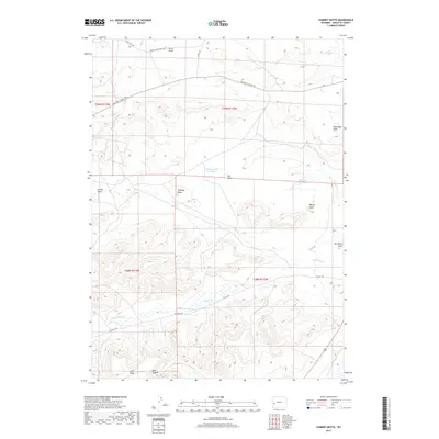
2017 Map of Chimney Butte
USGS Topo · Published 2017About this map
Chimney Butte stands as a central landmark in this high-desert landscape of southwestern Sublette County, where intricate drainage patterns define the arid terrain. The water management infrastructure necessary for ranching in this environment is evident through several small impoundments, including Chimney Butte Reservoir and Flat Top Reservoir. The map reveals a network of county and ranch roads, such as Big Piney Calpet Rd and Dry Piney Rd, which follow the natural contours of the land and its ephemeral waterways. Deeply incised features like Yose Canyon and McDonald Draw show how the periodic flow of Dry Piney Cr has sculpted the plateau. This 2017 survey provides a precise look at the modern land divisions and topographical features like Little Mesa and Bailey Cone that have served as navigational aids in this open range for generations.
Find a feature on this map
22 named features on this map. Tap any name to fly to it.
Don’t see what you’re looking for? This feature index may not catch every label — zoom into the map to look around manually.
Map Details
Editions of this 2017 Chimney Butte Map
This is the sole edition of this map. No revisions or reprints were ever made.
Other maps of this area

1939 · Big Piney
USGS Topo · 1:125,000

1942 · Big Piney
USGS Topo · 1:125,000

1955 · Preston
USGS Topo · 1:250,000

1958 · Preston
USGS Topo · 1:250,000

1962 · Preston
USGS Topo · 1:250,000

1969 · Chimney Butte
USGS Topo · 1:24,000

1969 · La Barge
USGS Topo · 1:24,000
1969 · Milleson Draw
USGS Topo · 1:24,000

1969 · Cretaceous Mountain
USGS Topo · 1:24,000
1969 · The Hogsback
USGS Topo · 1:24,000