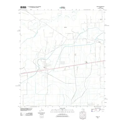
2010 Map of China
USGS Topo · Published 2010About this map
The settlement of China sits at the heart of this Jefferson County landscape, where the coastal prairie meets an intricate network of water management. The northern reaches are defined by the meandering Pine Island Bayou and its tributary, Cotton Creek, while the surrounding plains are etched with the infrastructure of the Lower Neches Valley Authority Canal. This elaborate system of waterways and canals, including the Gallier Canal, illustrates the region's historic reliance on irrigation for agriculture, specifically indicated by local thoroughfares like Rice Field Rd. Small communities such as Westbury, Meeker, and Pine Island are connected by a grid of rural roads, including Old Beaumont Rd and Old Nome Rd. In the northeastern corner, the Stonecipher Airport stands as a local aviation landmark, serving the dispersed residential and agricultural properties that characterize this part of Southeast Texas.
Find a feature on this map
40 named features on this map. Tap any name to fly to it.
Don’t see what you’re looking for? This feature index may not catch every label — zoom into the map to look around manually.
Map Details
Editions of this 2010 China Map
This is the sole edition of this map. No revisions or reprints were ever made.
Other maps of this area

1932 · Beaumont
USGS Topo · 1:62,500

1943 · Fannett East
USGS Topo · 1:24,000

1945 · Fannett East
USGS Topo · 1:31,680

1945 · Nolte
USGS Topo · 1:31,680

1950 · Houston
USGS Topo · 1:250,000

1954 · Beaumont
USGS Topo · 1:250,000

1955 · Sour Lake
USGS Topo · 1:62,500

1956 · Houston
USGS Topo · 1:250,000

1957 · Beaumont
USGS Topo · 1:250,000
1960 · Beaumont West
USGS Topo · 1:24,000