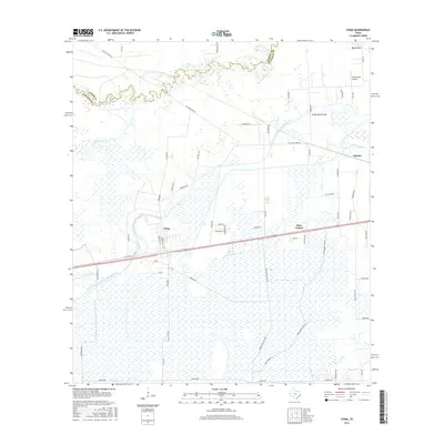
2016 Map of China
USGS Topo · Published 2016About this map
Pine Island Bayou snakes across the northern landscape, defining the winding boundary between Hardin and Jefferson counties. This coastal prairie region is heavily shaped by water management, with the Lower Neches Valley Authority Canal and the Gallier Canal cutting through the terrain to support local agriculture. The settlement of China sits at a crossroads of traditional routes and modern infrastructure, where Old Hwy 90 parallels the newer highway corridor. To the east, the small communities of Pine Island and Meeker are surrounded by a dense network of drainage features like Green Pond Gully and Byrd Gully. In the northeast corner, Stonecipher Airport stands as a local aviation landmark, while the southern reach of the quadrangle is dominated by the sprawling wetlands around Bayou Din, illustrating the region's low-lying, hydrologically complex character.
Find a feature on this map
63 named features on this map. Tap any name to fly to it.
Don’t see what you’re looking for? This feature index may not catch every label — zoom into the map to look around manually.
Map Details
Editions of this 2016 China Map
This is the sole edition of this map. No revisions or reprints were ever made.
Other maps of this area

1932 · Beaumont
USGS Topo · 1:62,500

1943 · Fannett East
USGS Topo · 1:24,000

1945 · Fannett East
USGS Topo · 1:31,680

1945 · Nolte
USGS Topo · 1:31,680

1950 · Houston
USGS Topo · 1:250,000

1954 · Beaumont
USGS Topo · 1:250,000

1955 · Sour Lake
USGS Topo · 1:62,500

1956 · Houston
USGS Topo · 1:250,000

1957 · Beaumont
USGS Topo · 1:250,000
1960 · Beaumont West
USGS Topo · 1:24,000