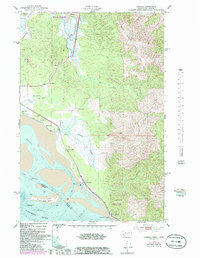
1984 Map of Chinook
USGS Topo · Published 1985About this map
Chinook sits at the northern edge of the Columbia River estuary, a landscape defined by the intersection of freshwater drainage and Pacific tides. This mid-1980s data includes bathymetric depths for Baker Bay and the Ilwaco Channel, revealing the underwater topography that guided coastal navigation. The map shows a transition from the marshy lowlands of the Chinook River to the steep rise of Bear River Ridge, with the Willapa National Wildlife Refuge protecting the northern wetlands near Willapa Bay. Several prominent family holdings, including Kyle Ranch and Goulter Ranch, are noted alongside infrastructure like the Port of Ilwaco Airport. Cultural landmarks such as Fort Columbia State Park and the Chinook Jetty provide a clear view of the defensive and navigational engineering required to manage the river's mouth during this era.
Find a feature on this map
28 named features on this map. Tap any name to fly to it.
Don’t see what you’re looking for? This feature index may not catch every label — zoom into the map to look around manually.
Map Details
Editions of this 1984 Chinook Map
This is the sole edition of this map. No revisions or reprints were ever made.
Other maps of this area

1919 · Astoria
USGS Topo · 1:62,500

1938 · Cape Disappointment
USGS Topo · 1:62,500

1938 · Fort Columbia
USGS Topo · 1:62,500

1939 · Astoria
USGS Topo · 1:62,500

1943 · Fort Columbia
USGS Topo · 1:62,500

1943 · Copalis Beach
USGS Topo · 1:250,000

1949 · Astoria
USGS Topo · 1:24,000

1949 · Chinook
USGS Topo · 1:24,000

1949 · Oman Ranch
USGS Topo · 1:24,000

1949 · Knappton
USGS Topo · 1:24,000