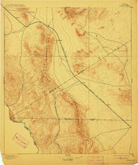
1897 Map of Chispa
USGS Topo · Published 1911About this map
The high desert terrain of Far West Texas is dominated by the Van Horn Mountains and the Tierra Vieja Mountains in this late nineteenth-century survey. Transportation through this arid landscape followed specific corridors, with the Southern Pacific R.R. and the Galveston Harrisburg and San Antonio Div. providing the primary rail links through stops like Chispa and Dalberg. Near the southwestern corner, the Rio Grande marks the international boundary between the United States and Mexico, its course flanked by the steep walls of Bass Canyon. The map reveals the critical importance of water sources in the Trans-Pecos, highlighting Van Horn Wells and Chispa Creek as vital landmarks for travelers and early settlers navigating the mountain passes like Vieja Pass.
Find a feature on this map
23 named features on this map. Tap any name to fly to it.
Don’t see what you’re looking for? This feature index may not catch every label — zoom into the map to look around manually.
Map Details
Editions of this 1897 Chispa Map
3 editions found
Other maps of this area

1892 · Chispa
USGS Topo · 1:125,000

1894 · Valentine
USGS Topo · 1:125,000

1895 · Chispa
USGS Topo · 1:125,000

1895 · Marfa
USGS Topo · 1:125,000

1895 · Sierra Blanca
USGS Topo · 1:125,000

1896 · San Carlos
USGS Topo · 1:125,000

1897 · Valentine
USGS Topo · 1:125,000

1897 · Eagle Mountain
USGS Topo · 1:125,000

1897 · Chispa
USGS Topo · 1:125,000

1906 · Van Horn
USGS Topo · 1:125,000